Land
Our Properties
The properties are located within the Gulf of Carpentaria region which is primarily suited to breeding beef cattle. Surrounding holdings are within a size ranging from 200,000 to 500,000 hectares.
There is extensive mining exploration and development in the region. A strong drawcard for tourists is the Lawn Hill National Park west of the aggregation.
The current state of improvements on both stations requires investment to achieve the herd growth scenarios desired. All improvements result in increased productive carrying capacity and asset value. To facilitate development and leverage growth, significant investments are being made in plants, water, yards and fencing.
Leases
LHRPHC holds the Lawn Hill and Riversleigh pastoral leases issued by the Queensland Government. These pastoral leases are located about 300 kilometres north of Mt Isa and 150 kilometres south west of Burketown.
Lawn Hill
Lawn Hill Pastoral Holdings 8/105 over Lot 4 on Crown Plan 849581. Containing about 510,955ha.
Riversleigh
Pastoral Development Holding 8/5399 over Lot 4 on Crown Plan GY805051 Containing about 192,135ha.
Lawn Hill is contained within the Burke Shire.
Riversleigh is contained within the Mount Isa City Local Authority Area and Burke Shire.
Land Description – Lawn Hill
About 230,000 hectares (42%) is open black soil plains heavily grassed with Bull Mitchell, some Flinders, Golden Beard, Blue and Brown Top grasses. There are extensive areas of timbered creek and channel country growing mostly Bauhinia, White Wood some patches of Bloodwood and gum with Coolabah and Gutta Percha within waterways. Grassed with White and Blackspear, Woolybutt, Blue and other perennial summer species to lighter carrying red gravelly sloping plains sustaining courser grass species including Woolybutt, White and Blackspear, Button and various summer grasses with light timbers including some Silver Leaf Box. This land form is the most productive and is associated with Lawn Hill, Archie, Musslebrook and Accident Creeks as bands almost centrally and along the eastern boundary running south to north.
About 239,000 hectares (45%) is primarily Broad Leaf Box, Snappy Gum and Spinifex on reddish clay loam soils, some being gravelly and stony to softer hollows and creek flats with Spear grasses, some Blue grass etc. This land form is of moderate productivity and best suited to breeding. It occupies a large section on the eastern side of the property (east of Lawn Hill Creek) and also south of the Nicholson River in the north western section. Areas of this land have only seasonal water supplies and limited artificial facilities.
About 60,000 hectares (12%) is hilly and steep stony ranges supporting some Spinifex and sparsely timbered with predominantly Snappy Gum.
Lawn Hill has about 340 kilometres of boundary of which about 260 kilometres is enclosed with cattle fences and the balance is natural barrier. It also has extensive internal sub division creating about 40 main grazing paddocks. Total internal fencing constitutes about 520 kilometres
There are a total of 60 artificial water facilities being either dams/earth tanks, bores, equipment on natural supplies and reticulated troughs.
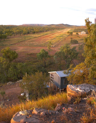
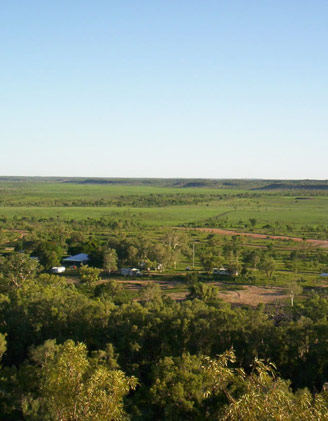
The Lawn Hill homestead compound is very well maintained with neat lawns and gardens and extensive development including a tennis court.
Lawn Hill has four separate cattle yards.
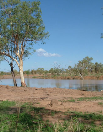
Permanent natural running water is available in Lawn Hill, Archie, Widdallion, Elizabeth and Accident Creeks. There is also an abundance of permanent natural water holes in various other creeks and the Nicholson River. Natural water is associated with the better class country types and is a feature of the property.
Land Description – Riversleigh
Land types on Riversleigh are relatively similar to Lawn Hill.
18,500 hectares (9%) consists of open black soil to lighter carrying red gravelly sloping plains. The black soil sustains a natural pasture of Flinders, Mitchell (mostly Bull Mitchell), Bluegrass, Golden Beard grass and various other summer species. The lighter red country has courser grass species including White and Blackspear grass, some Bluegrass, Woollybutt, Wiregrass merging to Spinifex. This is the most productive land form on Riversleigh.
About 40,000 hectares (18%) is Broad Leaf Box, Snappy Gum and Spinifex country with reddish clayey loamy soils, some being gravelly and stony to softer creek flats and hollows of better grazing quality due to palatable grasses such as Spear, Blue, Woollybutt etc.
Most of Riversleigh or about 159,500 hectares (73%) consists of hills and steep stony ranges with some Spinifex and stunted snappy gum. There are some narrow valleys and creek frontages of better grazing quality, however most of this land form is relatively hard.
Riversleigh has about 230 kilometres of boundary of which 190 kilometres is fenced and the balance consists of natural barriers i.e. hills and ranges. It has about 270 kilometres of internal fence lines creating about 10 main grazing paddocks, 2 smaller paddocks and a series of holding paddocks.
The artificial livestock watering facilities on Riversleigh include 19 bores and 3 pumps on the Gregory River and one at the homestead.
Riversleigh has a single set of stock yards at the homestead.
Environmental Features (Rainfall, Soils, Water, Weeds)
Rainfall
Isohyet maps indicate that the properties are located in 400mm to 700mm rainfall belts. The wet season generally occurs between the months of October to April, consequently there is a long dry period when the climate is generally regarded as arid.
Soils
Critical to high performance cattle breeding is the phosphorus status of the soils. Reconnaissance soil mapping suggests that the properties are likely to suffer acute P deficiency requiring phosphorus mineral supplementation of cattle during the wet season. However some of the river frontage alluvial soils have a high P status precluding the need for mineral supplementation.
Natural Water
Year round flowing streams (Gregory River and Lawn Hill Creek) are a major natural resource providing fail-safe stock water.
The northern side of the Gregory River has been fenced and watering points installed at strategic points to protect the River. Similar strategies are planned for Lawn Hill Creek over time.
Weeds
LHRPHC promotes a regional approach to rubber vine and noxious weed control, involving the Lawn Hill National Park and neighbouring property owners. LHRPHC has and will continue to work closely with Southern Gulf Catchments in the control of all noxious weeds.